Bukit Langkap: A Modest Hill With a Splendid View

By Rexy Prakash Chacko

August 2024 PEAKS AND PARKS
main image
Bukit Langkap.
Advertisement

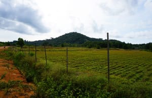
SLIGHTLY NORTH OF Bukit Mertajam is a low cluster of peaks, including Bukit Gua Gempas and Bukit Langkap, with the latter bordering the Butterworth-Kulim Expressway (BKE). While looking for a new place to hike in mainland Penang, I came across many online references to Bukit Suling— which, after research, turns out to be a spot located on the slopes of the 180m-tall Bukit Langkap. Looking at photos of its summit views, I am immediately convinced to plan a hike there.

We drive to Bukit Langkap from Penang Island, getting off the BKE at the Mengkuang turning. A few minutes later, we see an unpaved road to the left. A signboard reading “Suling Hill” confirms that this is where the hike begins. We turn in and park the car here before walking along the unpaved road and crossing a small bridge over Sungai Mengkuang. Before long, we reach an open area. A clear view of Bukit Langkap becomes visible ahead of us.

Historical references to Bukit Langkap are rather “uneventful”, except for the fact that the area was gazetted as a forest reserve in 1912, only to have this status revoked in the late 1920s. Since then, it has been used as cultivated land.

Walking to the right of this open area, we take a laterite track next to neatly planted rows of rubber trees, crossing paths with several hikers who are making their descent. About five minutes in, the path gently ascends the slope, surrounded by durian, jackfruit and mango trees. Trudging up this track, we spot a cluster of palm trees with huge leaves, and looking closer, we spot round, green fruits. Turns out, this is a Langkap palm (Arenga sp.)—the very plant that lends its name to the hill!

Higher up the hill, the trail becomes more exposed, providing better views. About 20 minutes into the hike, we reach a small rest shed where we make a quick pit stop. Looking toward the south, we get an uninterrupted view of the waters of Mengkuang Dam—the largest dam in Penang—which was completed in 1985, and expanded in 2011. Behind it, the towering peaks of Bukit Mertajam and Bukit Seraya rise in the distance.

View from Bukit Langkap towards Mengkuang Dam with the towering peaks of Bukit Mertajam and Bukit Seraya behind it.

After this rest shed, we spot a guest chalet, one of which immediately catches my attention as it has an ornately painted wall depicting pitcher plants, orchids and durian trees. As we stand appreciating this work of art, a fluttering orange butterfly in a patch of wildflowers nearby distracts me. It is a Tawny Coster butterfly (Acraea terpsicore), which has orange wings with speckled black spots. Originally found in open areas in India and Sri Lanka, it has been recorded further south in Peninsular Malaysia since the 1990s. Taking out our smart phones to quickly snap a few shots, we are surprised to find the butterfly staying still and cooperating throughout, spreading its wings in all its glory. Perhaps it knows that it needs to look good when featured in Penang Monthly!

Entrance to Suling Hill’s campsite and chalets.

It takes us another 10 minutes from the previous rest shed to reach the peak of Bukit Langkap, which is marked by a trigonometrical stone (T.S.) and a large signboard. We break here to celebrate our victorious ascent. While biting into a snack, my curiosity drives me to investigate the T.S. Gently moving my hands over its top to see if I could feel the outline of an etched numeral—as is common on a large number of these stones—I realise there is none, indicating that this T.S. belongs to an older, unnumbered series.

The trigonometrical stone (T.S.) on Bukit Langkap’s peak.

At the peak, we find that there is an alternative path down, and we follow the series of cement steps through a shady section of fruit trees. Occasional gaps in the canopy give us glimpses of the nearby Bukit Gua Gempas, whose sedimentary rock composition makes it a geological anomaly compared to Penang’s granite hills.

We are eventually led to the Suling Hill campsite and chalets, where there is a well-tended garden with a plethora of ornamental plants and huge sculptures of durians. The sculptures hint to the fact that, apart from glamping, this is a popular site for durian feasting—the six-acre compound houses about 15 durian varieties. There is a prominent view point here of the cityscape of Penang with its backdrop of rolling hills.

Fruits of the Langkap palm (Arenga sp.).

We trail the path out of the Suling Hill compound gently downhill and connect to another junction. Following the Strava app, we turn left onto an unpaved path as it skirts the BKE, occasionally seeing cars zoom past on the highway. Here, in the thin strip of vegetation separating us from the highway, I spot a common swamp pitcher plant (Nepenthes mirabilis) clambering over some ferns. While known to be the most widespread species of pitcher plants in the world, it is rather uncommon in Penang Island, and hence captures my attention. After taking a few photos, we continue along the flat path back to our car.

With its gentle terrain, fruit trees and superb views, Bukit Langkap is a short and pleasant hike on the mainland.

The summit of Bukit Langkap with a prominent TS.

Tawny Coster butterfly (Acraea terpsicore).

Cempedak.

The painted walls of a guest chalet.

Looking towards Bukit Gua Gempas.

Signboard on the way up to the peak of Bukit Langkap.

Huge durian sculpture at Suling Hill.

Common swamp pitcher plant (Nepenthes mirabilis).

Walking along the trail to Bukit Langkap.

Hike At A Glance

Length: 1 hour (complete loop)

Difficulty: Easy

Interest Level: Medium

Signposting: Yes

Likelihood of getting lost: Low

Number of hikers: Few

Rexy Prakash Chacko

is an electronic engineer by profession and a nature lover by passion. While he spends his weekdays earning a living at the Bayan Lepas Free Industrial Zone, his weekends are spent reflecting and recharging on the green hills of Penang.


`